How does a State line effect a change in the skyline? No - don't answer - clearly it doesn't; but in my view from the moment we cross into Montana, the sky really does seem bigger!! You can see for miles and miles in any direction. Trevor doesn't agree.
The 'Big Sky' nickname was made popular by a Montana State Highway Department in the 1960's and refers to the unobstructed skyline in the state that seems to overwhelm the landscape. Truly!!
 |
| One last photo ...! |
We have had a wonderful time once again! A great big 'thank you' to you all.
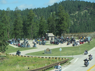
As we make our way north, we run into bikes ... they are everywhere!! This is Sturgis week after all.


The sight, and sound, of so many Harleys is amazing!!
We have about 270 miles to go today - to North Dakota. Once we leave Spearfish we are into open prairie - the highway stretches out in front of us - trucks replace bikes.
 The next day we cross into Montana and the 'big sky' thing happens ... for me!
Our plan is to head for Glacier National Park in the northwest of the state but there is a lot of country to cross first.
We are exploring Montana for the first time - (although not entirely correct as we came across the state line a few weeks ago when we visited the Little Bighorn National Monument.)
 We call into a Visitors Centre at Wibaux MT, popn about 700! We receive tons of advice and information, not to mention maps and brochures. A highlight is to find good coffee in such a small place -with iced biscotti!!
We prefer to drive on principal roads, not interstates, so we start our exploring in the northeast of the state.

We pass mile after mile of wheatfields; some have been harvested; also mile upon mile of freight cars waiting for grain.
As we head north the land changes. We are into badland country similar to that in North and South Dakota. There are very few cars; long stretches of highway without seeing another car.
Simple grandeur is in abundance! The earth and sky melt into each other with endless horizons. Grand vistas are mixed with sandstone formations, barren and dry.
Island mountain ranges, buttes, river breaks, badlands and largely untouched plains all make up this big, big 'place'.


We feel insignificant as we make our way along Hwy 24.
 |
| The dam at Fort Peck Lake |

And then we find the Missouri River - again!
 The centrepiece of northeast Montana is undeniably the Missouri River. It was the route of western expansion and became Montana's connection to the rest of the country.
We cross the Fort Peck Dam, the highest of six major dams along the Missouri River. The dam creates Fort Peck Lake the fifth largest man-made lake in the US, more than 130 miles long, 200 ft deep and with a 1,520 mile shoreline.
 |
| Even the dandelions are enormous! |

We stop in Glasgow ... yep .. named after Glasgow, Scotland.
 The guy in the site next to ours - who lives and works in Glasgow - says it is an 'outpost'! He is being critical of the lack of funding for roads and infrastructure in the northeast, but after travelling across such vast open spaces I think his description is most apt!
 Glasgow is only about 50 miles from the Canadian border.
The sunset is beautiful - as seen from the RV!


No comments:
Post a Comment